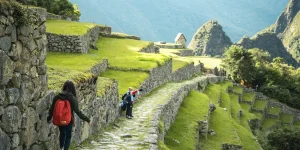
The famous city of Nazca brings people from all over the world to see the incredible mystery of the Nazca lines. Located in the southwest of Peru, Nazca is capital to the province of the same name. Being south of Lima it takes around 7 hours to travel from Lima to Nazca by bus. The history of this area dates back as far as 100 BC when the first signs of the Nazca civilization start to appear.
Climate of Nazca
Situated on the southwestern coast of Peru, Nazca’s climate is extremely arid and hot with average yearly rainfall around 4mm. The dessert on the coast of Peru is one of the driest places in the world. Nicknamed the land of eternal sun the weather doesn’t really change year round. Average temperatures generally range from 59°F(15°C) to 86°F (30°C). The low precipitation and lack of wind have helped preserve the Nazca Lines for thousands of years.
Geography
Nazca has a population of approx. 40,000 people and is only 1,710 ft (520 m) above see level. Located about 280 miles (450km) from Lima it’s around a 7-hour ride from Lima to Nazca. The capital of the Nazca province it is a biggest city in the region. The surrounding landscape is a flat desert that extends until the foothills of the Andes to the east. Nearby is the legendary Cerro Blanco one of the worlds tallest sand dunes at 6,820 ft (2,078 m).
Nazca History
The Nazca civilization starts with the founding of the region by what was the Paracas civilization somewhere around 100 B.C. and lasted until somewhere around 600 A.D. Known for their pottery and textiles the Nazca that created many spiral shaped underground aqueducts called puquios. The puquios channels run down into underground water canals pushing water to where it was needed. This method of transporting water underground limited the amount of water loss due to evaporation. The technique made it possible to cultivate various different crop types including, cotton, potatoes and beans among others. The creation and use of these aqueducts are a display of the Nazca’s civilization understanding hydraulic engineering and agricultural practices.
Evidence shows that around 500 A.D the civilization started to decline and was completely gone by around 750 A.D. It appears there was widespread flooding all across the region due to a strong El Niño season. It’s possible that the removal of most of the Prosopis Pallida trees to make room for agriculture was a contributor to the mass flooding. The Pallida trees play an important role in soil erosion. The mass flooding led to the destruction of the agricultural systems leaving the society without a reliable food supply.
Society
The civilization was made up of local chiefdoms that would largely govern themselves. These chiefdoms would occasionally collaborate and act in unison for mutual interests. The presence of alpaca llama and vecuña wool is evidence of long-distance trade with communities from the highlands. These animals cannot survive in the arid landscape of coastal Peru and so is proof of trade between communities. Excavated tombs where Nazca mummies were buried offer the most valuable Nazca artifacts. These artifacts offer great insight into the reality of the Nazca society.
Elaborate pottery and textiles were found buried with mummies in addition to the elongation of some of some skulls. Some graves were designed to be reopened so more mummies could be added. Trophy heads were often found accompanying the mummies with holes in the center of the forehead so multiple heads could be placed on a single cord or string. These heads were also commonly depicted on pottery and textile art. Additionally, sacrificial victims are also common, often times buried with their eyes and mouths sealed shut using cactus needles. Crippled by the generation long drought the Nazca were finally conquered by the nearby Wari tribe who adopted many of their pottery and textile techniques.
Ventilla
The urban capital of the Nazca was Called Ventilla and spanned over 2 square kilometers. The city included walled courtyards terraced housing and ceremonial mounds. In order to combat the everlasting arid conditions, the use of underground aqueducts and cisterns were used in order to supply water year-round.
Cahuachi
The religious and most important ceremonial site of the Nazca, Cahuachi dates back to 100 B.C. A site of pilgrimage thought to be sacred because it’s one of the few locations in the region with a year long water supply. However, archeological evidence suggests the area was never inhabited. The site covers 11.5 square kilometers and has 40 different large adobe mounds with the largest reaching 20 meters high. All of the mounds are connected to a plaza and have adobe walls. Some mounds are the sites of burials where as most contain evidence of ritual feastings where trash was left at the mound. Generally speaking, the larger the mound, the more rituals had taken place.
The principal god the Nazca worshiped is described as the Oculate Being. Often depicted with large eyes and a snake like tongue. This being would usually be flying and have streamers of trophy heads hanging from his neck.
Nazca Lines
Discovered in 1927 by Peruvian archeologist by the name of Toribio Mejia Xesspe. There is another set of lines in the nearby city of Pala. The Pala lines were discovered in 2018 with the use if drones. Approximately 25 new lines have been discovered which are thought to be at least 1 thousand years older than the lines in Nazca.
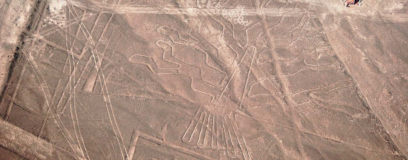
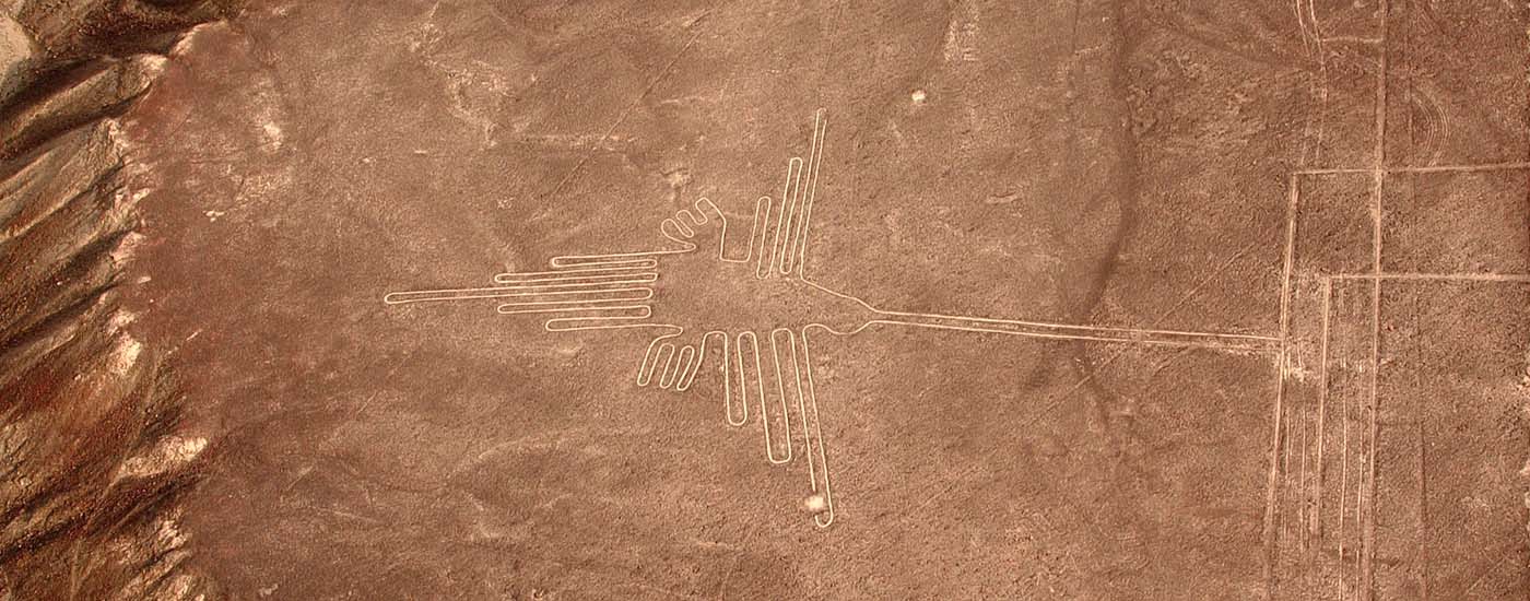
The main attraction of the region that brings thousands of people every year from all over the world. A series of geoglyphs which required large scale community cooperation in order to create. The Lines are shrouded in mystery and their exact purpose is still open to debate. There are many different theories, some theories suggest the lines are some sort of large astronomical map, whereas the other more fantastical theories involve alien activity.
The main accepted theory is that desert stones, which had been discolored due to years of sun exposure, were moved exposing the brighter sand or earth below. The stones were then placed around the exposed brighter earth creating a contrasting boarder. Whatever the truth, archeological evidence has been found that points to the use of string and stakes in order to make long straight lines. Wooden stakes have been found at some of the Nazca line sites.
There are two main groups of lines one group near the city of Nazca and the other farther north close to the city of Palpa. The most famous Nazca lines are the Monkey, Hummingbird, and the spider however there are many different depictions of plants animals and geometric shapes. The size of the lines varies but generally speaking they are not visible from the ground and must be seen by airplane.
How to see the Nazca Lines
In order to see the Nasca lines you must take a plane. Generally speaking, the cost starts around $80 and can go as high as $300 depending on how many lines you want to see and if you want to also see the lines in the nearby city of Palpa. The ride usually is 30 – 45 mins depending on the how much you paid. Some lines are positioned on hills and so are visible from the ground but, most are made on flat ground and so cannot be seen. While on the plane ride you will also get a chance to see the bizarre spiral shaped pits called puquios.
- Cost: $80 – $300
- Duration: 30 – 45 mins
***PLEASE NOTE: You cannot see the lines from the ground and will need to take a plane in order to see them
Nazca Packing List
- Sunscreen: In the land of eternal sun protecting yourself is very important
- Day bag: Small day bag for personal items
- Water bottle: reusable water bottle
- Hat and sunglasses: for further sun protection
- Long clothing: Long pants and long sleeve shirt for sun protection
- Camera: Digital camera unless your pone camera is Good enough